|
|
Table of Contents
Oxford Center Renewal Plan
|
3. Strengths,
Weaknesses, Opportunities and Threats Appendix A – Draft Oxford Center Village
District Zoning Amendment |
The centers and downtowns of Connecticut
communities have traditionally served as the focus of the community.
Connecticut towns were established around their churches, located on or near
the Town Green. Commercial establishments followed, and town centers developed.
Over the years, the role of the town centers
changed and evolved. In some communities, the town centers evolved into
“downtowns,” serving commercial, community, employment and spiritual needs of
the residents. In other communities,
the role was more limited, sometimes only serving a limited commercial and
community role.
The importance of the Town centers was diminished
during the latter half of the twentieth century. The growth of Connecticut
communities during this period was based upon almost universal access to
automobile transportation. The growth of commercial services occurred in
locations and sites that were convenient for automobile access and parking. Traditional
town centers usually lacked this convenience, and their role as the commercial
focus of the community diminished. Commercial development occurred along major
roads and, where it was possible to provide ample parking.
However, in recent years there has been a renewed
interest in community centers. Many communities have recently realized the
importance of a focus or center as a determinant of the character of the
community. Communities have also realized their importance as an economic
resource, both as a source of commerce and as a community attraction.
The role of Oxford Center has evolved within this
general context. In contrast to its more urban neighbors, such as Naugatuck and
Seymour, Oxford has remained a rural community and was never a center of
commerce or production.
Oxford has experienced rapid residential growth over
the past several decades. However, given its large geographic area, and rural
heritage, the growth has been scattered across the community. Commercial
development has occurred in Oxford to partially serve this growing population,
but none of it has been in Oxford Center. Even with a population of almost
11,000, Oxford residents still obtain a vast majority of their retail goods and
services outside of the town. However, Oxford Center has remained the
governmental center of the community, with the Town Hall, Library, Police
Station and currently expanding Center School.
Unlike
most town centers, Oxford Center has a distinctly residential character. The
residences are interspersed with churches, with municipal uses anchoring the west
side of the Center.
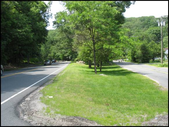
Oxford
Center is linear in nature, stretching approximately three-quarters of a mile
along Route 67. The southeastern entrance is Victory Park and the intersection
of the Old State Highway, with the Town Hall defining the northwestern edge.
As
small as the Town Center is, it contains three distinctive land use areas which
were used in the analysis and formulation of this plan, the Southeast Gateway,
Historic Core, and municipal area. Each has its own distinctive character and
subject to different land use factors. The Southeast Gateway is the area from
Victory Park to Riggs Street. It is somewhat separate from the rest of the Center
and is the least developed area. The Historic Core is centered upon the Green,
including the churches and relatively intensive residential uses. The Municipal
Area includes the Town Hall, Center School and Fire Station.
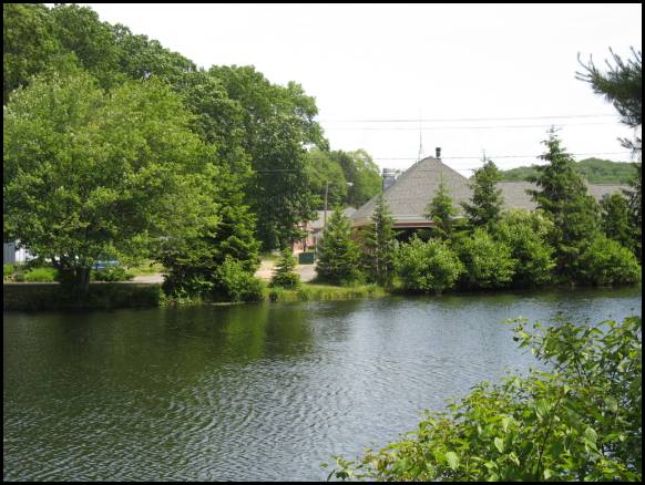
Victory
Park defines the southeastern entrance to the center. The park consists of a
narrow stretch of land along the Little River between Route 67 and Old State
Highway. Access to the park is difficult from Route 67 with the best access
from Old State Highway. The park is somewhat separated from the rest of Oxford
Center by the intersections of Route 42 and Riggs Street.
There
are several homes on the north side of Route 42, just east of the intersection
of Route 67. The realignment of the intersections of Route 42, Riggs Street and
Route 67 created a small parcel of vacant land on the northeast side of Route
67, between Riggs Street and Route 67.
There
are additional residences to the northwest along the road towards Dutton Road.
The property across from the intersection of Dutton Road is vacant. Although a
portion of it is within the floodplain of the Little River, most of the
property is useable.
Saint
Peters Church is on the other side of Dutton Road, separated from the Oxford
Police station by a small parking lot. Governors Hill Road intersects Route 67
just northeast of the police station. Several residences are across the road
from the church and police station, up to the Town Green. At this point, the
Little River is just behind the properties fronting on the southwest side of
the road.
The
Town Green is on the northeast side of the road. Academy Road surrounds and
frames the Green, linking it with the surrounding residences and the
Congregational Church. The Oxford House Restaurant is across the road from the
Green, with a parking lot along the road. There are several other residences on
the southwest side of the road.
At
this point, the Municipal Area of Oxford Center begins. There are only two
privately owned uses on the southwest side of the road, a residence, and an
attorney’s office, across from the Town Hall. Much of the remainder of the area
on this side of the road is town owned space. It was part of a residential
subdivision that was dedicated to the Town.
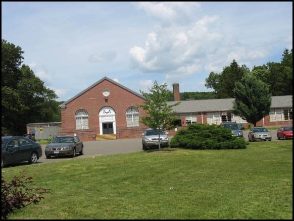
The
Oxford Center School is on the northeast side of the road, located on a large
parcel with temporary buildings to the rear. The school is setback from the
road, behind a lawn and parking area. The central firehouse, Grange, and Town
Hall are all northwest of the Center School
An effective development plan for any area or
neighborhood requires a certain consensus on the overall vision. An
understanding of the underlying strengths, weaknesses, opportunities and
threats that impact the area is necessary in the formulation of this vision. A
meeting was held with the stakeholders committee to identify, discuss, and
assess the strengths and weakness of Oxford Center.
Strength - Architectural Characteristics
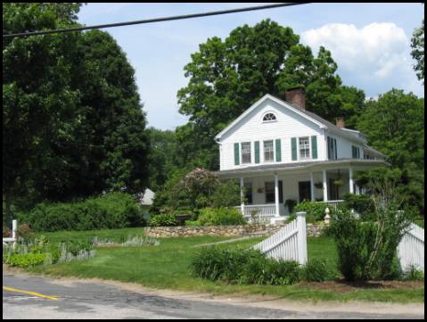
The growth of
Oxford over the past several years has had little impact upon the historical
character of the area. This has resulted in a minimal impact upon the area’s
historic character. The Upper Green is
the central focus of this historic area, bounded by the Congregational Church,
and historic homes.
The historic character of the area is also enhanced
by the Oxford House, the Grange and the historic homes and churches that line
Oxford Road between Riggs Street and the Center School. Although there are
mid-twentieth century homes in the area, the overall historic character has
been retained.
Strength - Little
River
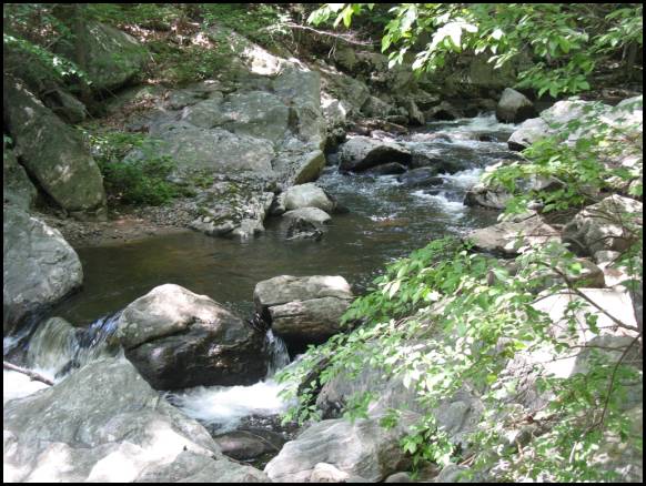
The Little River runs through Oxford Center,
closely paralleling Route 67. Within the northern part of the study area, the
river is close to the road. As it flows south, the river winds to the south of
the properties on the south side of the road. It crosses Route 67 just south of
the intersection of Riggs Street, and forms the heart of the Lower Green. The
Little River has important town wide significance, as well as it defines the
“central valley” of Oxford.
Strength - Public
Spaces
Oxford Center has retained many public owned spaces
that are available for the enjoyment of the citizens of Oxford, including the
Upper Green, Lower Green, Town Hall and Kirk’s Pond, Center School and the
recently acquired open space across the street from the Town Hall. These
properties are all under direct control of the Town and can be used for public
benefit.
Strength - Visibility
Oxford Center is literally located within the
center of the town, astride the most heavily traveled road in the community.
Route 67 links Oxford Center with the south end of Oxford and Seymour to the
south, and into Southbury on the northwest. According to the State Department
of Transportation, approximately 13,000 vehicles per day pass through Oxford
Center on Route 67.
Strength - Grange
Building
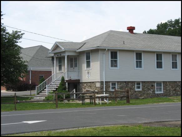
The Grange Building, located just southeast of the
Town Hall, was an important focus of Oxford’s agricultural community. Although
the role of agricultural in Oxford has declined, the Grange still serves as a
community meeting space.
Strength
- Municipal Buildings
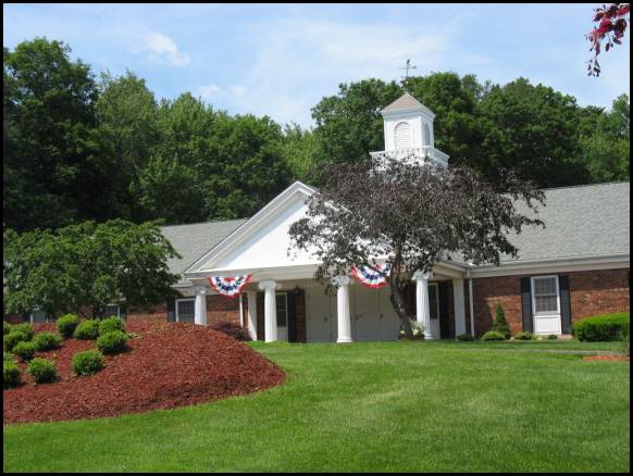
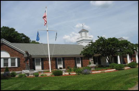
Oxford Center has remained as the civic and
governmental center of the Community. The S.B. Church Town Hall was constructed
approximately thirty years ago on the north edge of Oxford Center. The Library
is in the basement of the Town Hall. The Oxford Center Fire Station and Center
Elementary School are adjacent to the Town Hall, and the Police Station is
across the street.
Over the years, the public and civic role of Oxford
Center has remained its most important function. Municipal business is
conducted in the Town Hall, and students and teachers use the Center School.
Although expansions and additions to the municipal facilities will be needed in
the near future, it is important that Oxford Center retain its role as the
municipal center of the community.
Strength - Kirks
Pond
Kirks Pond is located immediately adjacent to the
Oxford Town Hall, just behind the Grange building. The lower front Town Hall
parking lot is just west of the pond.
Although
it is located within the complex of municipal buildings, Kirks Pond has a low
visibility and utility. No building or public spaces are oriented towards the
pond. However, with changes, the pond has the potential to serve as focus for
park or public space.
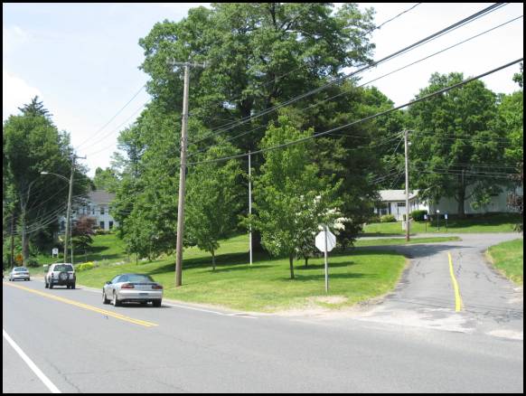
Weakness - Traffic
Volume
Although the visibility of Oxford Center is strength,
the volumes and speed of traffic traveling along Route 67 detract from the
environment of Oxford Center. The traffic volumes have been steadily increasing
due to increased development in Oxford and surrounding communities.
Perhaps more significant than volume is speed, and
the traffic maintains its speed as it travels through Oxford Center. There are no traffic signals, stop signs,
crosswalks or any other traffic control devices that cause the traffic to stop
or slow down. Although the speed limit in Oxford Center is 25 mph, few vehicles
appear to slow down to that speed. As a result, the overall feel and impression
of the area is that of land along a highway.
With increased residential and commercial
development projected in Oxford and surrounding communities, traffic on Route
67 will continue to increase, which is likely to result in the need for future
road improvements. The intersection of Route 67 and Route 42/Riggs Street was
improved several years ago to accommodate the increased traffic to be generated
by the Oxford Greens residential development. However, as more development
occurs along Riggs Street, and there is more traffic along Route 67, additional
intersection improvements are likely to be needed in the near future, possibly
including a traffic signal.
Weakness - Lack of
Sense of Place
The major difference between Oxford Center and
other, more vibrant town centers is that Oxford Center lacks a strong “sense of
place.” A “sense of place” is the perception of the geographic area as
containing features or characteristics that define the area as recognizable,
cohesive, and distinctive. This sense of place can manifest itself in a strong
focal point, such as a town green, or prominent building, but it needs to
contain elements that tie the area together. Currently, Oxford Center is a
collection of related buildings along a stretch of highway, but lacking
unifying elements.
Weakness - Lack of
Parking for Churches
Aside from the municipal buildings, the churches
are the most significant uses within the Center and generate the most activity.
Both churches lack adequate parking, particularly for the major holidays or
events. On-street parking is not an option.
The parking lots at the Central School and Town Hall
could be used by the church attendees during periods in which there would be
little or no need for municipal parking. However, this is difficult as there
are no sidewalks, and no way in which pedestrians can safely and conveniently
walk from the municipal parking lots to the churches.
Weakness - Environmental
Limitations
Oxford Center is within a narrow valley of the
Little River, with steep hillsides on the south side of the valley, separating
the Center from the residential neighborhoods to the south. The topography on
the north side is a bit more gentle, although there are areas of steep
hillsides rising to the plateau of northern Oxford.
The Little River is a scenic and environmental
asset to the area, and helps define its character. At the same time, the
watercourse, and its accompanying flood plain and wetlands, do limit potential
development that may be beneficial to the Center. Within the western area of
the Center, the Little River runs near Route 67, allowing only a narrow area of
non-wetlands, along the road. This prevents any significant level of
development from occurring there. Further east, the river is behind the
properties fronting on Route 67. However, it is still a barrier and constraint
to any significant type of development within the area.
The river also limits the potential for use of the
town –owned open space on the south side of Route 67, across from the Town
Hall. Improvements would require a crossing of the Little River and the
associated wetlands. The land rises sharply immediately to the south, and its
slope and topography would make any substantial improvement difficult.
Weakness - Pedestrian
Unfriendly
A key characteristic of any successful, functional
town or neighborhood center is the ability to “park once” and walk around the
area to the various destinations. Oxford Center lacks any pedestrian
circulation system, as there are no sidewalks along Route 67 linking the
various components and uses with Oxford Center.
Weakness - Cross
Streets
Most town centers in Connecticut grew and evolved
around an intersection of at least two major roads, linking the community with
surrounding communities. These roads are now usually state highways. Nearby
examples of this are easy to find; Naugatuck; Routes 63, 68 and 8; Beacon Falls;
Routes 8 and 42; Seymour; Routes 67, 313 and 8; Southbury; Routes 67, 6 and 84;
Prospect; Routes 68 and 69; etc. Although Routes 42 and 67 intersect in Oxford
Center, Route 42 is a minor road and does not access much of Oxford.
Much of the Oxford community is southwest of Oxford
Center, and there are no major through roads that connect Oxford Center with
the entire western section of Oxford. Town roads, such as Governors Hill Road
and Hogs Back Road provide the principle connections to the central and west
areas of Oxford, but these roads are hilly and narrow, and not up to standards
of state highways. Consequently, residents in the western sections of Oxford,
along Route 188, are not well connected to Oxford Center.
Busy town centers are naturally located at the
junction of at least two major highways, as the location can benefit from
accessibility from different areas of the community. Oxford Center does not
enjoy this level of accessibility.
Weakness - Poor
Visual Appearance
Despite the historic buildings and environmental
attributes, Oxford Center does not present a favorable visual image. When
approaching from the northwest, the entrance is defined by the bus garage.
Although there are no such negative images when approaching from the south, the
visual image lacks the unity and cohesiveness that would let people know that
they are entering a special place.
Weakness - Utilities
There is no public water or sewer service in Oxford
Center. The need to provide on-site water and sanitary waste disposal for each
individual property limits the potential intensity of development that can
occur on the site.
Sanitary sewer service has been extended up Route
67, and the Town’s utility service plan calls for an ultimate extension into
Oxford Center.
In addition, the area contains overhead utility
wires that detract from the historic character of the area.
The growth and development of Oxford present a
variety of opportunities for the improvement of Oxford Town Center:
Opportunity - Maintain
Area as a Municipal Center
Oxford Center has maintained its role and
importance within the community as the Town’s governmental center. This is
currently its most important role, and should be continued as a primary
function into the future.
Opportunity - Preserve
Historical Character
One of the important characteristics of Oxford
Center is its historical character and role in the history of the Town. The
historical components of this area are primary assets of Oxford Center, and should
be a principal component of any sustained improvement effort.
Opportunity - Commercial
Uses
Commercial uses are commonly located within most
community centers or downtown areas. Oxford Center has been unique in that it
contains few commercial uses. The major commercial uses within Oxford are
further south along Route 67.
It is not feasible that Oxford Center will ever be
a major commercial center of the Town, because of environmental limitations,
lack of developable land and existing land use patterns. The goal of
maintaining the existing character of the area would prevent any intensive or
large scale commercial uses. However, the introduction of limited, small scale commercial
uses can enhance the character of the Center, by serving as an additional
attraction and reason for people to use the center.
Opportunity - Highway
Realignment
The intersection of Routes 67, 42 and Riggs Street
have been realigned several times over the course of the past several decades.
An early realignment left a stretch of road east of the Victory Park, which
serves a shortcut between Routes 42 and 67.
The intersection was reconstructed several years
ago, in conjunction with the reconstruction of Riggs Street. The Riggs Street
and Route 42 intersections with Route 67 were separated, creating a small
parcel of land between the roadways.
As traffic increases within the area, additional
improvements to the intersection may be necessary, including the introduction
of a traffic signal. It may be advisable to close the old state highway at one
end to reduce traffic evading the intersection.
Opportunity - Oxford
Center School
The presence of the Oxford Center School reinforces
the governmental presence in the center, and its role as an activity center.
However, the overall makeup and status of the school is being evaluated, and
the future use of Oxford Center School is uncertain at this point. If its use
as a school no longer meets the needs and plans of the Board of Education,
there will be opportunities for re-use.
One promising option is for it to be used as the
Town Hall. Many communities have successfully adapted a school building for use
for municipal offices. This would free up the existing Town hall for re-use
and/or private redevelopment. It could be redeveloped into a small scale office
– retail complex, or re-used for governmental functions such as an expanded
library or recreational / senior center. The site includes considerable land to
the rear of the building which could be used for recreational or community
purposes.
Opportunity - Parks
and Greenways
The analysis of the strengths indicated that the
two of the most important strengths are the Town Greens, Little River and Kirks
Pond. These can all be weaved into a
greenway system that creates important public spaces and links them with a
system that would befit Oxford’s rural heritage.
The role of Oxford Center within the community has
evolved over the years. This evolution continues and change is required to
improve the area and make it an important and vital component of a growing,
contemporary community. The role should reflect the collective vision of the
Oxford Center stakeholders.
Although there were several important components,
the overall theme or vision that emerged from the discussion and analysis can
be stated as follows:
In order to meet the needs of the twenty-first century, Oxford Center
needs to become more of a gathering place and focus for the community. This includes
Improvements to make the area more comfortable for residents, and the creation
of facilities and businesses that would attract more residents. At the same
time, the historic and environmental characteristics of the area must be
maintained and enjoyed.
Although the area has
inherent strengths, generally, it is not a place that people feel comfortable
spending much time there, other than a specific destination. People tend to spend the minimum amount of
time in Oxford Center to accomplish their task, whether it is to conduct
municipal business, go to church or attend school.
There are several important components to making
Oxford Center more of a community gathering place and focus.
1. Pedestrian Linkages
There are no accommodations for any pedestrian
activity in Oxford Center. The area has no sidewalks or walkways. Walking along
the road is uncomfortable and sometimes dangerous, as vehicles travel at high
speeds despite the 25 MPH speed limit. The stretch of Route 67 within the
Center contains no traffic control devices that would enable a pedestrian to
cross the road.
A system of sidewalks and walkways is needed. It
should include a sidewalk along the northeast side of the street between Town
Hall and Riggs Street. Pedestrian circulation on the southwest side of the
street could include a combination of on-street walkways and a path along the
river. There should also be internal walkways connecting nearby facilities,
such as the Center School, Kirks Pond and Town Hall.
2. Business
The growing population of Oxford is creating new
business opportunities. The town is experiencing a great deal of retail
“leakage;” residents leaving town to conduct business. Additional business
development would enhance the role of Oxford Center as the focus of the
community, as it would create another reason for people to visit the center.
However, the physical layout, residential character and historic
characteristics of the area make it imperative that any retail or related uses
be small-scale in nature, and of a nature that is consistent with the historic
and residential character.
Although there are some limited opportunities for
new construction to accommodate businesses, the emphasis should be on the
continued re-use of the existing buildings within the area, with continued
strict standards for site design. Any new construction should be of a scale and
quality so that it also blends into and enhances the area.
The commercial uses should be small scaled and
respective of the historic and residential character within the area. Art
galleries, professional offices, studios, antique shops and similar uses would
be appropriate within this area. The current Oxford Center zoning permits a
limited range of commercial uses in existing buildings. However, some new
buildings may be appropriate, such as on the vacant parcel on the north side of
Route 67, just west of the intersection of Riggs Street.
3. Community and Government Center
The role of Oxford Center will be strengthened by
locating the future municipal facilities within the town center, including the
library, senior center and expanded town hall. However, for some facilities
like the police station, other locations within the Town may be more
advantageous.
Similarly, the churches are important components of
the center, and should remain.
4. Parks and Greenways
The key to making Oxford Center a more interesting
and inviting place is to create a system of parks and greenways within the
area, essentially an open space ribbon through the area. The ribbon would tie
the area together, linking activity centers with open space resources. These
open space resources should include Kirks Pond, the Little River, the land
behind the Town Hall, and both Town Greens.
5. Historic Resources
Oxford Center has a strong heritage that should be
utilized in its improvement efforts. Many of the homes and churches in the area
are historic. The Green and the surrounding buildings encompass a unique and
valuable historic resource. Any improvement efforts should be based upon and
respective of the historic character of the area.
6. Visibility
Even with pedestrian improvements, vehicular
traffic will continue to dominate in and through Oxford Center. The area needs
to be better defined, with entrance features that let everyone know that they
are entering a unique area of the community.
7.
Town Role
Oxford
Center, along with other sections of the Route 67 Corridor extending south
towards the Seymour town boundary should be considered as the “central spine”
of Oxford. Although Oxford Center is not the central retail area, it is part of
the corridor which collectively provides much of the focus and activity of the
community. Therefore, future land use decisions should be made to reinforce
this role. Oxford Center should be viewed as the historic and civic anchor to
this corridor.
There
are recommendations for each of the sub-areas of Oxford Center, as well as
general area wide recommendations. The recommendations are physical,
programmatic and regulatory, to provide a multi-faceted approach for the
renewal of Oxford Center.
1. Southeastern
Gateway
This
is the area southeast of the intersection of Riggs Street, and includes the
Victory Park. As stated previously, it is somewhat separated from the rest of
Oxford Center. The plan for this area includes the following:
a. Install an entrance feature at the south end of
Victory Park to inform motorists that they are entering Oxford Center. This
should include a sign and distinctively landscaped area.
b. Maintain the homes along Old State Highway as
residences.
c. Landscape the “leftover” parcel of land between Riggs
Street and Route 42.
d. Request the State Department of Transportation to
investigate the feasibility of a traffic light at the intersection of Route 42
and/or Riggs Street.
e. Permit limited non-residential uses on properties
along Route 67.
2. Historic Core
This
area is what is perceived when people speak of Oxford Center. It includes the
green and surrounding historic areas, as well as both churches. It includes the
area between the Center School and the intersection of Riggs Street. The area
includes some historic non-residential uses, but is still dominantly residentially
in character.
a. Redesign the Town Green by:
§
Creating a passive recreational area for Town residents
§
Open up views of the
Congregational Church, possibly by select tree trimming or removal.
§
Create pedestrian
linkages between the Green and other areas of the Center.
§
Allow for the use of the
homes along the Green for certain limited non-residential uses, such as a Bed
and Breakfast, or professional office. This may require some relaxation of the
parking requirements.
b. Consider permitting the development of the vacant
parcel on the northeast side of Route 67, across from Dutton Road for a small
scale commercial development. The development should incorporate careful architectural
and site design that is in conformance with the historic character of the area.
c. Install landscaping between the Oxford House parking
lot and the road, to reduce the visual impact of the parking lot.
d. When a new Police Station is constructed, reuse the existing
building for office or small scale retail uses. The site has room for
additions, but the parking areas should be well landscaped and shielded from
view from the road.
Re-use of the site may require demolition of the
existing building and reconstruction. Should that occur, the new development
should be designed is a scale and style consistent with the historic context of
the area around the Green.
e. Permit the use of the existing homes for limited
retail and office uses.
3. Municipal Area
a. The Town Hall should remain within Oxford Center;
either at it existing location, or at the Center School, if the Board of
Education decides that the Center School is no longer needed or appropriate for
educational needs.
b. If the municipal offices are moved to the Center
School, and the existing Town Hall building is not needed for other municipal
purposes, the existing site of the Town Hall should be redeveloped into a
retail commercial area, with a village like character. This may require the
demolition of the existing Town Hall.
c. Kirks Pond should be improved into the principal town
green in the area. It should be designed and improved to be the primary outdoor
public space in the community, and a focus for community activities.
d. If the Center School is reused as a Town Hall, the
area behind should be integrated into the overall center park system.
e. The lands behind the Town Hall and across the street from the Town Hall should also become part of the overall center park system. They can serve as a base of a trail system through Town open space.
4. Overall
1. Zoning
a.
Village District Regulations - Village Districts are specially enabled
by State Statute to provide a higher level of review for specially designated
areas of the Town. It offers the opportunity for a higher level of
architectural and site control. The jurisdiction would also apply to public
rights-of-way, including the State Highway. Oxford Center would be eligible for
the creation of a Village District. The statute states that the village
districts must be located within areas of distinctive character, landscape or
historic value that are specifically identified in the plan of conservation and
development of the municipality.
The adoption of Village
District regulations would enable the regulations of the design and placement
of buildings, maintenance of public views, design, paving materials and
placement of public roadways, and other elements that the Planning and Zoning
Commission deems appropriate to maintain and protect the character of the
village district. This higher level of review would enable changes in use in
Oxford Center, in accordance with the Village District Controls.
b.
The current Oxford Center zoning regulations permit limited commercial
uses in existing buildings, with minor additions. The regulations should be
amended to permit more commercial uses within Oxford Center, with strict
architectural and site guidelines.
c.
The zoning regulations should include lower parking requirements for
business uses within Oxford Center, and also include incentives for shared
parking. Parking areas should be visually deemphasized, with screening from the
road. The goal should be to encourage use of the municipal parking facilities
and minimize parking impacts within the historic core.
2.
Parks and Open Space
The
existing and potential park and open space resources within Oxford Center are
unique for Town centers. However, these collective resources are not
effectively functioning as assets to Oxford Center. The individual park and
open space resources should be improved to a linking “green necklace”
throughout Oxford Center. This should include the following:
§
Greenway and paths along
the Little River.
§
Enhancement of Kirk’s
Pond to serve as the Town Green within the municipal area, with linkages to the
Center School and Town Hall. This area should be designed to serve as a central
feature of Oxford Center.
§
Improvement of the
Church Green to open up views of the Congregational Church.
§
Creation of an entrance
feature at Victory Park that lets people know that they are entering Oxford
Center.
3.
General
1. Install sidewalks along both sides of Oxford Road between
Town Hall and the Church Green.
2.
Extend sewer service
up Route 67 as far as the Town Hall, and provide sewer service to the
properties within Oxford Center.
3.
To the extent
feasible, new and expanded municipal facilities that provide services to
residents should be located within Oxford Center. Although there may be
significant financial reasons to construct a new library further up Route 67,
other municipal facilities such as a senior center and expanded Town Hall
should be located within Oxford Center.
4.
Work with the State
Department of Transportation to install a traffic signal at the intersection of
Riggs Street – Route 42 and Route 67.
5.
Work with the State
Department of Transportation to install a crossing walk signal in the vicinity
of the Center School in conjunction with the construction of sidewalks. This
can be done in conjunction with installation of the sidewalks.
6. Provide a systematic planting scheme along Route 67 within
Oxford Center that includes street trees and ground plantings.
7.
Any center revitalization
or enhancement efforts require an entity to advocate for the interests of the
businesses and property owners within the area. Unlike other centers or downtowns
of larger communities, Oxford Center has not had a strong identity that would
foster the creation of this type of group.
However, within the long term planning
horizon, this type of group can be effective in furthering the unique interests
of Oxford Center. In order to begin the process of advocacy for Oxford Center,
the Oxford Economic Development Corporation should establish an Oxford Center
working committee, whose role would be to further implementation of the
recommendations of this plan.
8. It is generally accepted that revitalization of downtown
areas within large and smaller communities are significantly enhanced by
residential development in or near the downtown area. This provides a market
for downtown businesses, and enhances the role of the area as a 24 hour
activity center.
Oxford Center is not a downtown, in the
sense of communities such as Naugatuck, Seymour, Derby, Ansonia or Shelton.
However, some additional residential population within close proximity of the
Oxford Center would enhance its role as the community center. It is important
that this residential development occur in a design and scale that is
consistent with the overall character of the community. Age-restricted housing,
at a slightly higher density than otherwise permitted in Oxford has proven successful
and consistent with overall planning and land use goals. Therefore, the zoning
regulations should provide for age-restricted housing, at higher densities than
otherwise permitted near Oxford Center. The extension of sewer service into
this area would facilitate this type of development.
Appendix A – Draft Oxford Center Village District Zoning Amendment
The following is a draft
amendment to the Town of Oxford Zoning Regulations that incorporates the
recommendations of this Plan. It includes the establishment of a Village District,
in accordance with Section 8-2j of the State Statutes. Additions are underlined
and deletions are crossed out.
SECTION 1
General.
1.1
Authority – The
regulations for the Oxford Center District shall be considered a Village
District in accordance with the requirements of Section 8-2j of the Connecticut
General Statutes.
1.2
Purpose – It has
been determined that the area within the Oxford Center Zoning District is an
area of distinctive character and historic value, which has been so determined
by the Oxford Plan of Conservation
and Development. The purpose of these regulations is to protect the distinctive
character of
SECTION 2
Permitted Uses.
Land,
buildings, and other structures may be used for one or more of the following
purposes:
2.1 All uses permitted in the Residence A
District as specified in Article 5, Section 2.
SECTION 3
Special Exceptions.
Subject to the securing of a Special
Exception as provided in Article 10 of these regulations, the following are
permitted:
SECTION 4
Applicability and Standards.
The following standards shall apply
to all special exception uses specified in
Article 8A, Section 3, except those uses permitted as per Article 8A,
Section 3.1.
4.1 No parking areas shall be
located between the building and the public right-of-way, except the driveway.
4.2 All parking areas shall
be shielded from view from the public right-of-way and adjacent properties
through the use of evergreen hedges, lumber fence, masonry walls or other
measure determined to be suitable by the Commission.
4.3 All parking areas shall
be setback a minimum of 10 feet from all side lot lines and 15’ from the rear
lot line. The Commission may waive the setback when the adjacent property is
being used for nonresidential purposes and a common parking area is used.
4.4 These
uses shall utilize existing buildings.
The Commission may permit the expansion of an existing building or the
construction of a new building if it finds that the architecture of the new
construction is compatible with the historic architecture within the area.
4.5 All signs shall conform
to the requirements of Article 16, and shall reflect the historic nature of the
area, in the opinion of the Planning and Zoning Commission. No internally
illuminated signs shall be permitted.
4.6 All other requirements of
the Residence District A shall apply.
4.7 All
uses by Special Exception shall utilize buildings that exist at the time of the
adoption of this regulation. Such
buildings, if they contain less than 2,500 square feet of floor area, may be
enlarged so that the special exception use occupies a maximum of 2,500 square
feet of floor area, if, in the opinion of the Commission, the expansion of the
building will not detract from the historical and residential character of the
area. All additions and alterations to existing
structures shall be consistent with the requirements of "Connecticut
Historical Commission- The Secretary of the Interims Standards for
Rehabilitation and Guidelines for Rehabilitating Historic Buildings."
4.8 The
Commission shall consider the design, relationship and compatibility of
structures, plantings, signs, roadways, street hardware and other objects in
public view. Specifically, the Commission shall consider the following factors
in its review of all applications:
(a) that
proposed buildings or modifications to existing buildings are harmoniously
related to their surroundings, to the terrain and to the use, scale and
architecture of existing buildings in the vicinity that have a functional or
visual relationship to a proposed building or modification,
(b) That all spaces and structures visible to the
public from public roadways are designed to add to the visual amenities of the
area consistent with those of the village district in and around the proposed
buildings or modification,
(c) that the color, size, height, proportion of
openings, roof treatments, building materials and landscaping of commercial or
residential property and any proposed signs and lighting be evaluated for
compatibility with the local architectural motif and the maintenance of views,
historic buildings, monuments and landscaping, and
(d) That the removal or disruptions of historic
traditional or significant structures or architectural elements are minimized.
4.9 All
development in the village district shall be designed to achieve the following
compatibility objectives:
(1) The building and layout of buildings and
included site improvements shall reinforce existing buildings and streetscape
patterns and the placement of buildings and included site improvements shall
assure there is no adverse impact on the district;
(2) Proposed streets shall be connected to the
existing district road network, wherever possible;
(3) Open spaces within the proposed development
shall reinforce open space patterns of the district in form and siting;
(4) Locally significant features of the site such
as distinctive buildings or vistas shall be integrated into the site design;
(5) The landscape design shall complement the
district's landscape patterns:
(6) The exterior signs, site lighting and accessory
structures shall support a uniform architectural theme if a theme exists and be
compatible with their surroundings; and
(7) The scale, proportions, massing and detailing
of any proposed building shall be in proportion to the scale, proportion,
massing and detail in the district.
SECTION 5
Landscaping.
All ground area which is not covered by building,
paving or natural vegetation, which has been disturbed by construction, shall
be graded to a slope not steeper than 1:3 and planted and seeded so as to
establish a permanent ground cover which will enhance appearance and inhibit
erosion of soil. The landscaping shall
be designed to promote the historic and residential character of the area.